

Solo Ride – May Day, Monday 1st May, 2017
My Ride (according to Strava)
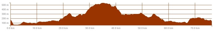
Total Distance: 76 km / 47 miles with 1,243 metres of climbing
Ride Time: 3 hours 18 minutes
Average Speed: 23.1 km/h
Temperature: 13°C
Weather in a word or two: Cool
And now for something a bit different …
All the chatter about the south of the river being like Mordor and covered in dark, impenetrable clouds that my club mates fear to penetrate, had only served to remind me just how much I enjoy the challenge of riding there and so I decided to scratch the itch.
May Day, Bank Holiday Monday seemed to provide the perfect opportunity. There was of course a club run available, but since these tend to consume pretty much a full day and the family were struggling to remember what I looked like, an early start and early return from a solo ride under Sauron’s baleful eye seemed like a good compromise.
It also meant I didn’t feel the need to provide any blerg commentary and reportage but would give me something else to write about should I unexpectedly and inexplicably feel the urge. I guess I did.
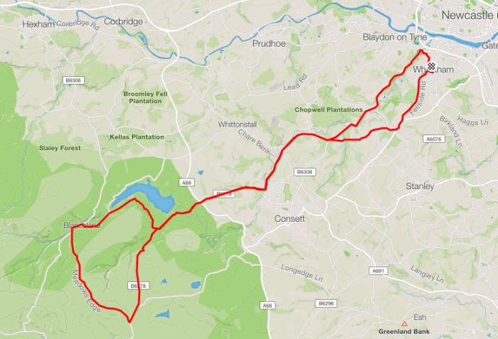
I was up early and on the road by 8:15, dropping down the Heinous Hill and then swinging around to put the River Derwent on my left as I began to head south-west, directly up its valley.
I was off into the Land of the Prince Bishops (which sounds slightly more appealing than Mordor) and beginning what Strava notes as my longest ever climb – around 25km in length with an altitude gain of 440 metres.
Although it rises fairly relentlessly all the way, the first part of the route is very much about gentle, almost unnoticeable climbing with only a few relatively gentle humps and bumps to warm up the legs and get the blood flowing.
A sharp right at Shotley Bridge soon changes all that and here the serious stuff begins. A short, swoop over the hump-backed bridge provides a little momentum for the start of the long climb of Burnmill Bank.
It’s not enough.
Momentum quickly evaporates around the first corner and the road starts to rise and just goes on and on, up through the delightfully named hamlet of Snod’s Edge.
This is about the halfway point of the climb, which totals around 4.5km in length at a 5% average gradient. Strava has it flagged as a 3rd category climb.
I had no idea how Strava categorise their climbs – so I looked it up. Apparently it’s based on the official UCI system, but whereas the UCI may take into account the severity of the preceding route when classifying climbs for races, the Strava categorisation is wholly objective and is based on multiplying the length of the climb (in metres) with the grade of the climb in percent. If the resulting number is greater than 8,000 and the grade is 3% or higher, then the climb is categorised. The categories are then:
HC >80,000
Cat 1 >64,000
Cat 2 >32,000
Cat 3 >16,000
Cat 4 > 8,000
This would imply a Cat 3 climb is twice as hard as a Cat 4, but of course it doesn’t always work like this.
The road surface on Burnmill Bank is reasonable and most of the way it cuts through woods which provides shelter as well as a bit of colour and variety. It wasn’t long before I was encouraged to stop and strip off gloves and arm warmers.
Traffic was fairly light this early in the morning (to be fair, it usually is up here) and the verges were the playground for lots of very young and excitable rabbits, many of whom seemingly hadn’t seen a cyclist before and tended to sit up and watch me ride by, rather than bolting for cover.
Cresting the top, the trees fall away to either side and you’re presented with the first look at Weardale and the North Pennines in all their beautifully bleak and exposed glory.
Scuttling across the busy main road, leads you onto an exhilarating and fast descent down toward the source of the Derwent river and its namesake reservoir – often speckled with the bright sails of dinghy’s but looking flat, grey and empty today.
The road drags and climbs a little past the reservoir, before you reach Edmunbyers, then if you follow the road around to the left a swooping descent leads you across a jarring, juddering cattle grid. This is the gateway to moors where you can look up and up … and up some more, along the route you’re about to take.

I pass and greet a group of mountain-bikers as I rattle and thrum across the cattle-grid. They’re all well wrapped up against the weather, rain jackets and tights and boots and I feel slightly under-dressed.
I start climbing, round a few hairpins and then the wide road stretches out, relatively straight and upwards, lined by snow poles running up either side, like an extreme minimalist’s idea of a grand boulevard.
The air seems still and quiet out here, the silence only occasionally disturbed by a few bleating lambs and the haunting whoop-whoop-whorree of some long-beaked, moorland birds. Curlews perhaps? I’m no ornithologist, so it’s just a guess.
The incline is constant, but fairly steady and I settle down to spinning my way upwards. Distinctive features slowly emerge ahead and reaching and then passing them at least gives me some measure of progress.
In this way a road sign, the entrance to a dirt track, a passing place, an up-rooted cats-eye and a strangely shaped heathery hummock all gain significance as they’re encountered and put behind me.
One undistinguishable lump by the side of the road coalesces into the bloated body of a dead sheep, flat on its back, legs sticking stiffly up in the air like a massive dead fly, then this too is passed by.
Ahead the road appears to disappear over a low crest, but reaching this point reveals it continues still, upwards and onwards, but now clinging to the wide bowl of the fell as it sweeps gently around the landscape. Off to the left somewhere, the Waskerley Reservoir apparently lies in a hidden dip. I’ve not seen it yet.
As the road straightens, it also flattens slightly and I start to pass other cyclists heading in the opposite direction. A sign announces I’m 5½ mile from Stanhope and within striking distance of the stiff climb of Crawleyside. This is featured in Simon Warren’s 100 Greatest Cycling Climbs, 6,190m long with average 4% and max of 20% in sections and he rates it 7/10.
I’ve ridden it a couple of times, but don’t find it especially challenging or particularly engaging, so it’s not on the menu today. Instead, I’m taking a right hand junction Google Maps has revealed to loop around and then descend down Meadow’s Edge, to Bale Hill and on to Blanchland.
As I take the right hand turn, the previously unnoticeable wind suddenly makes itself felt, it’s fairly strong and gusty and carries a distinctively chill edge. I stop briefly to reclaim arm warmers and gloves from my back pocket and then press on.
The road reaches its peak, topping out at about 545 metres above sea level, and then starts to slowly descend as I press on through a somewhat destabilising cross-headwind. Sweeping round, I’m heading more or less due north now, the descent steepens and I pick up speed.
Ahead, the road surface looks newly laid, unblemished and feels as smooth as glass. I can clearly see there are no cars and I find myself whooping and swooping round the curves, tucked in tight and able to safely use the full width of the road.
I notice signs proclaiming 15% and 20% ramps as I whip past downhill, passing another lone cyclist going in the opposite direction and attempting what looks like a shorter but harder way up to the top. Then I’m through another, much gentler cattle grid and descending on suddenly much rougher roads through Baybridge and on to Blanchland.
I stop in Blanchland for a much deserved cereal bar and guzzle from my bottle, saluting several small groups of cyclists as they swing past, while I begin plotting a route home. Either way I need to climb out of the village, going left and up a 20% plus climb out toward Slaley and along the top of the fells, or right, to a clamber out and trace the edge of the reservoir, followed by a longer, but less sharp climb out of the valley again.
The right hand route is more scenic and less exposed, so that’s the way I head, passing through Edmunbyers again, before climbing back up to Burnmill Bank.
I’m soon racing through Snod’s Edge again and trying to build up enough speed to carry me down a sudden dip and up the stinging climb on the other side. Naturally I don’t make it and there’s a bout of undignified out of the saddle grunting and gurning as I try to keep the big ring turning over.
Back into the Derwent Valley, I retrace my route, but this time in the opposite direction and it’s all encouragingly, slightly downhill. I tuck in, ramp things up and I’m soon clipping along at a fairly respectable 20 mph plus.
At Hamsterly I sweep left and then right and I’m onto the final climb of the day, the 4th category hill up to Burnopfield. From the top, it’s a short skip down Fellside Road and I’m home – only around 47 miles covered, but packed with over 1,200 metres of climbing. I can’t help feeling there’s plenty more good roads to ride and climbs to find out here in the Mordor badlands.
Seeing my ride posted on Strava, the BFG wondered how much my legs were burning and I truthfully told him I was fine. Well, that was until Mrs SLJ pressed me into fulfilling my familial commitments with a walk down to my parents house and back again. I can honestly say this proved a much more taxing exercise than my morning ride.
YTD Totals: 2,557 km / 1,589 miles with 27,868 metres of climbing

Wish we had some hills in Northamptonshire worth climbing
LikeLike
Then you too could develop a love/hate relationship with them?
LikeLike
Might be a typo in the Crawleyside gradient Mr SLJ. I wish it was 6k at 14%, it would be the me mecca for UK cyclists, instead of the merely uncomfortably painful one it is.
LikeLiked by 1 person
Ah, thanks. I’m pretty sure I was just quoting from the book, but I’ll check.
LikeLike
Well, there you go, I’m going to blame fat fingers and crap one-fingered typing – the average gradient should be 4%. Fixed now – thanks again.
LikeLike
Looks like a great ride! I’ve found some good climbs in Kent recently. Moving up that Strava leaderboard…
LikeLike